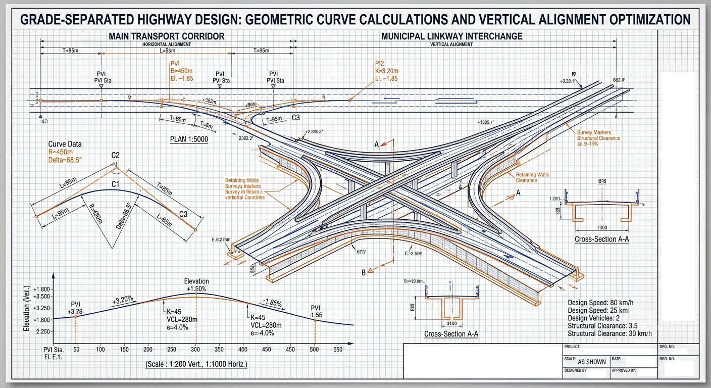
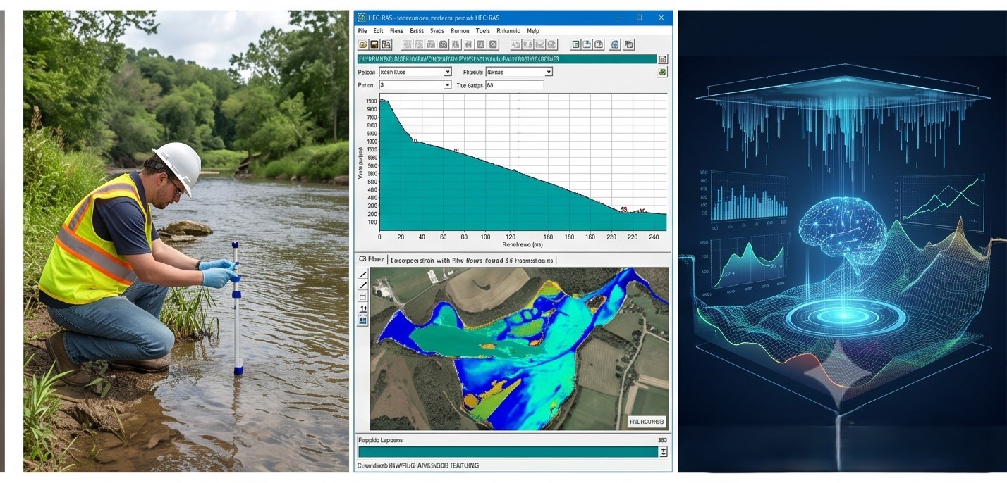
Home Services Projects About Contact

Engineering Consultancy — Est. 2026

Translating structural parameters into built reality

Our engineers bring over 11 years of field experience in structural analysis, spatial mapping, and transport corridor design — anchoring every project to verifiable precision.

Project Sheet
General Capability Index
Experience
0 yrs / engineer
Projects Completed
0
Tolerance Standard
±0.002 mm
Terrain Surveyed
0 ha
Active Clients
0
Delivery Accuracy
99.8%
GL ±0.000 FOUNDATION — 12,000 mm × 2,500 mm 16,400 mm APPLIED LOAD P = 450 kN
Structural Section, Typical Bay Dwg. No. STR-001 — Rev. C

What We Do

Six integrated engineering disciplines under one roof

Topographic & Underground Surveys

Spatial positioning, subsurface utility tracing, and terrain anomaly detection to establish verified coordinate baselines before design begins.

97%Survey Accuracy

GIS Mapping & Geospatial Integration

Structuring geographic datasets into layered functional models for master planning, land-use analysis, and infrastructure routing.

92%Coverage

Highway Geometry & Transport Corridors

Horizontal and vertical alignment design, superelevation, sight-distance verification, and earthwork quantity computation for road and rail corridors.

99%Precision

Structural Engineering & FEA

Finite element load distribution, wind-shear analysis, seismic response evaluation, and connection design with strict factor-of-safety tolerances.

98%Rigor

CAD, BIM Modeling & Digital Twins

Clash-free coordination models, 4D scheduling, quantity extraction, and as-built verification using industry-standard BIM platforms.

95%Fidelity

Hydrological & Hydraulic Modeling

Watershed delineation, flood-return-period analysis, stormwater network sizing, and coastal erosion modeling for civil and environmental projects.

94%Resilience

How We Work

From field survey to signed-off drawings

Step 01

Survey & Capture

Field data acquisition — total station, GNSS, GPR — before any model is opened.

Step 02

Modeling & Analysis

Datasets resolved into coordinate-accurate design models and simulation runs.

Step 03

Optimization

Iterative refinement — material, geometry, cost — against code tolerances.

Step 04

Delivery & Review

Stamped drawings, calculation books, and transparent performance reporting.

Have a project that needs engineering clarity?

Talk to our team for a confidential technical assessment — no obligation.

Services

Full-spectrum engineering services backed by 11+ years of hands-on expertise

Each discipline reinforces the next — survey feeds modeling, modeling informs analysis, analysis drives design.

Topographic & Underground Surveys

Total station and GNSS positioning, ground-penetrating radar for utility tracing, and terrain anomaly detection. We establish verified coordinate baselines before any design model is opened.

97%Survey Accuracy

GIS Mapping & Geospatial Integration

Multi-layer geographic datasets structured into actionable planning models — land-use classification, infrastructure routing, environmental constraint mapping, and site suitability analysis.

92%Coverage

Highway Geometry & Transport Corridors

Horizontal and vertical alignment design to AASHTO / international standards, superelevation transitions, sight-distance verification, cross-section templates, and earthwork quantity computation for road and rail corridors.

99%Precision

Structural Engineering & FEA

Finite element load distribution, wind-shear analysis, seismic response spectra, connection design, and buckling checks with strict factor-of-safety adherence across steel, concrete, and composite members.

98%Rigor

CAD, BIM Modeling & Digital Twins

LOD 300–400 Revit/Civil3D models, clash-free MEP coordination, 4D scheduling, automated quantity take-off, and as-built verification for infrastructure and building projects.

95%Fidelity

Hydrological & Hydraulic Modeling

Watershed delineation, flood-return-period analysis (2-yr to 100-yr), stormwater network sizing, culvert hydraulics, and coastal erosion modeling for civil and environmental compliance.

94%Resilience

Applied Analytics & Automation

Custom scripts and parametric workflows for batch quantity extraction, repetitive drawing generation, and large-dataset spatial analysis — reducing manual effort by 40–60%.

90%Throughput

Project Index

Selected validation cases from our portfolio

450 hectare topographic and utility survey projectGISSUR-014

Subterranean Utility & Topographical Array

Multi-layered spatial mapping across 450 hectares of terrain — subsurface utility detection, contour generation, and coordinate benchmarking to eliminate infrastructure collisions during construction.

Grade-separated highway corridor geometry projectTransportTRN-027

Grade-Separated Corridor Geometries

Horizontal and vertical alignment design for a municipal linkway — superelevation, curve widening, sight-distance checks, and earthwork quantity verification to zero deviation.

Finite element structural load analysis projectStructuralSTR-118

Finite Element Load Distribution Arrays

Structural load permutations, wind-shear resilience evaluation, and connection design for a multi-storey steel frame — strict factor-of-safety adherence throughout.

100-year hydrological flood model projectHydrologyHYD-009

Dynamic Coastal Hydrological Model

Digital twin of a coastal watershed boundary — 100-year precipitation flood risk mapping, culvert sizing, and erosion prediction for environmental clearance.

About Us

Our engineering philosophy

"Trust in engineering is not granted — it is empirically proven."

We operate under the belief that infrastructure is an exact translation of classical mechanics. Our approach eliminates guesswork by anchoring every design variable to a verifiable coordinate baseline before a single drawing is issued.

Our name references the Almagest — the ancient treatise on mathematical astronomy that set the standard for empirical precision. We apply that same rigour to modern engineering: verifying load paths, checking tolerances, and validating models before physical work begins.

Our team brings over 11 years of combined field and design-office experience across structural, spatial, and transport disciplines. When managing complex, high-value infrastructure, we deliver engineering packages that demonstrate performance transparently — calculation books, model audit trails, and stamped drawings.

Our Process
Survey & Empirical Capture

Ground-truth data before any model is opened.

Computational Modeling

Coordinate-accurate design models and simulations.

Structural Optimization

Iterative refinement against code tolerances.

Sign-off & Delivery

Stamped drawings and transparent reporting.

Established 2026 • Technical Standards Absolute

Contact

Let's discuss your project

We work with enterprise clients, infrastructure developers, and institutional planning groups.

Response time
We respond within 24–48 hours on business days.
Confidential
All project inquiries are treated under NDA by default.
Remote & on-site
We serve clients globally with field teams deployable to your project location.
Direct line
Speak with an engineer, not a sales desk.